CBS News
Northern California braces for snow storm with Blizzard Warnings in effect. Here’s the forecast.

SACRAMENTO — A severe winter storm has begun bringing copious amounts of snow to the Sierra Nevada in Northern California this week through the weekend. Extremely dangerous mountain travel is expected, with long stretches of roadway becoming impassible with blizzard conditions.
First Alert Action Days:

CBS13
Blizzard Warnings are in effect for the Sierra and Foothills from Thursday morning to Sunday morning, with the heaviest snow falling Thursday night to Friday afternoon and again Friday night.

Heavy snow and strong winds will combine to result in white-out conditions and extended power outages, especially above 3,000 ft. This will be the coldest and snowiest storm of the season so far.
For those living in the Sierra, be sure to have your emergency supplies before the storm begins. Check your smoke detectors and CO detectors to be sure they are functioning. During the storm, be sure all exhaust vents around your home are clear from debris and snow.
Storm Summary:
- Blizzard conditions; zero visibility, strong winds and extremely heavy snow
- Snowfall rates will approach 2-4 inches per hour
- Strong to damaging wind gusts to 60-80 mph are expected over the mountains. Over 100 MPH gusts will be possible over mountain ridgetops.
- Heavy snow and strong winds will result in white-out conditions. We could see mountain closures at ski resorts.
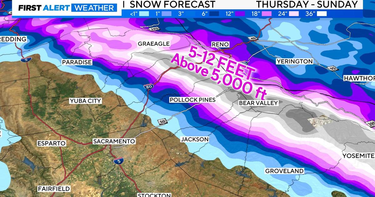
- Snowfall totals are projected between 5-12 feet for elevations above 5,000 ft.
- Mountain travel will become extremely dangerous to impossible, especially on Friday.

Storm timing
Once this storm moves in, rain and snow will spread southward through the day Thursday.
Road conditions are expected to deteriorate rapidly in the Sierra. The snow will quickly become heavy with snowfall rates ranging between 1-3″ per hour. Snow levels will start between 4,000-5,000 ft. and then lower to 2,500-3,500 ft. by Friday.
The most severe part of the storm will impact the Sierra on Friday. Snowfall rates will approach 2-4 inches per hour with whiteout conditions and near-zero visibility at times.
Anyone venturing outside in these conditions may easily become disoriented. Therefore travel is not recommended across the Sierra. Expect hard closures across mountain passes.
Strong winds are expected to develop over the Sierra on Thursday and Friday, with gusts reaching 65 mph. High winds combined with heavy snow may cause tree damage and extensive power outages, especially at elevations above 3,000 ft. These winds are expected to peak on Friday and then taper off through the weekend.
Across the Valley
For the Sacramento Valley, the impact will be far less. Light to moderate rain is expected in the valley on Friday with a low chance for embedded thunderstorms.
Thunderstorm development is dependent on whether we get any clearing in the cloud cover. Any thunderstorm that develops will be capable of producing heavy rain, lightning and small hail. Otherwise, the main impact on the valley will be limited to large puddles and ponding of water on the roadways.

Wind will also begin to pick up as this storm moves through.
Models have increased wind gusts across the valley, especially across the Northern Sacramento Valley on Friday.
Gusts up to 40-45 MPH will be possible for most on Friday, with stronger wind gusts closer to Marysville, closer to 55 MPH.

The strongest wind will be over the Sierra with gusts up to 60 MPH.
Storm total precipitation will vary greatly with elevation. The valley is expected to receive anywhere from 0.5 – 1.5 inches of rain.

Over the weekend
By Saturday, the most intense part of the storm for the Sierra will be behind us but the temperatures will continue to fall. This will result in lowering snow levels down to 2,000 ft, where minor snow accumulation may occur.
There is a chance snow levels may drop further from time to time with little to no accumulation at those elevations. The storm starts to move out Sunday morning with a sharp improvement in overall weather conditions Sunday afternoon.

Again, this will be our coldest, snowiest storm of the season with large amounts of snowfall expected by Sunday in the Sierra.
Storm total snowfall is projected between 5-12 feet for elevations above 5,000 ft. and 1-4 feet for elevations above 3,000 ft. Minor accumulation is possible down to 2,000 ft. this weekend.

The greatest snowfall amounts will be realized just west of the Sierra ridge line, especially at elevations above 6,000 ft.


Travel across the Sierra will likely be tricky well after the storm comes to an end as crews work to clear the roads. Expect chain controls through the weekend as CalTrans cleans up.
Make sure to check road conditions before you travel here. Also stay up to date with the CBS Sacramento First Alert Weather team for what to expect through this 4-day storm.


Watch CBS News
Be the first to know
Get browser notifications for breaking news, live events, and exclusive reporting.
CBS News
$100 million in federal funds released for North Carolina to rebuild roads, bridges damaged by Helene

Washington, D.C. – The U.S. Department of Transportation released $100 million in emergency funds on Saturday for North Carolina to rebuild its roads and bridges damaged by Helene.
“We are providing this initial round of funding so there’s no delay getting roads repaired and reopened, and re-establishing critical routes,” said U.S. Transportation Secretary Pete Buttigieg in a statement. “The Biden-Harris administration will be with North Carolina every step of the way, and today’s emergency funding to help get transportation networks back up and running safely will be followed by additional federal resources.”
The storm caused rampant flooding that has devastated several towns and killed more than 225 people – with CBS News confirming at least 114 people killed in North Carolina. There was more than 8 inches of rain across the western North Carolina mountains, with some areas seeing more than a foot.
Hundreds of roads across Western North Carolina remain closed, leading to an increase in air traffic as teams scour the region for survivors by air. Air traffic over Western North Carolina has increased by 300% due to relief efforts since the storm cleared, the Federal Aviation Administration and the North Carolina Department of Transportation.
Mudslides blocked Interstate 40 and other highways in North Carolina and about 400 roads were closed due to damage from Helene. Interstate 40 was damaged at several locations, the Department of Transportation said.
President Biden visited the Carolinas on Wednesday, surveying the flood damage by air from Greenville, South Carolina, to Asheville, North Carolina. Mr. Biden announced the federal government would cover “100%” of all debris removal and emergency protective measure costs in North Carolina for six months.
The Department of Transportation said these relief funds will allow the North Carolina Department of Transportation to act more quickly to fund eligible repairs to their damaged facilities.
Li Cohen and
contributed to this report.
CBS News
Tropical Storm Milton forms in Gulf; forecast to strengthen into hurricane headed toward Florida
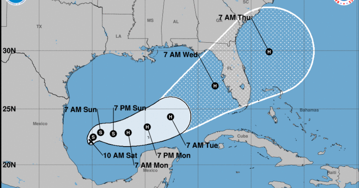
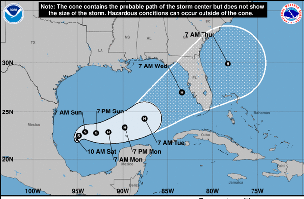
Tropical Storm Milton has formed in the Gulf of Mexico and is forecast to strengthen into a hurricane headed toward Florida with possible impacts to its western coast, the National Hurricane Center said on Saturday. Maximum sustained winds are expected to be at 40 mph with higher gusts and Milton is currently moving north-northeast, NHC said in an advisory.
Milton is forecast to undergo a period of rapid intensification before it makes landfall as a Category 2 hurricane across Florida’s west coast, CBS News Miami reported.
The forecast comes a little more than a week after Hurricane Helene made landfall in Florida and across the Southeast, killing more than 200 people and causing immense destruction. President Biden on Thursday took an aerial tour of Florida’s Big Bend where Helene struck as a Category 4 storm. Hundreds of people are still missing and Mr. Biden said the work to rebuild will cost “billions of dollars” as communities suffer still without power, running water and passable roads.
NOAA
Milton is forecast to move across the southwestern Gulf of Mexico through Sunday night then across the south-central Gulf on Monday and Tuesday before reaching Florida’s west coast by the middle of the week, NHC said. Heavy rain is possible in the region starting Sunday into Monday, CBS Miami reported, and more rain and heavy winds will most likely arrive on Wednesday. Hurricane and storm surge watches will most likely be required for portions of Florida starting Sunday, the National Hurricane Center said.
Along with the heavy rainfall, the hurricane center said to expect risks of flooding.
Residents in the area should ensure they have a hurricane plan in place, the National Hurricane Center said, follow the advice of local officials and check back for forecast updates.