CBS News
D.C’s cherry blossoms just hit their earliest peak bloom in 20 years. Here’s why scientists say it’ll keep happening earlier.

The iconic pink and white blossoms that transform Washington, D.C. at the beginning of spring have officially hit their earliest peak bloom recorded in at least 20 years. It’s one of the earliest days it’s happened in the area on record – and experts say it will likely keep shifting earlier.
Peak bloom occurs when 70% of the Yoshino cherry blossoms planted around D.C. open up. According to the National Park Service, this usually happens between the last week of March and the first week of April. From 2004 to 2023, the annual peak mostly occurred between March 25 and April 10, with a few exceptions where it happened as early as March 20.
The service predicted on its website that peak bloom would occur this year between March 23 and March 26, but in an update on Sunday, the service’s National Mall and Memorial Parks posted an update on social media.
“PEAK BLOOM! PEAK BLOOM! PEAK BLOOM! Did we say PEAK BLOOM?!” the agency said. “The blossoms are opening & putting on a splendid spring spectacle.”
The agency confirmed peak bloom arrived on March 17 on its website on Monday. But what exactly makes them open up earlier? Scientists and National Park officials say it all has to do with the weather.
“Peak bloom varies annually depending on weather conditions,” the service says, adding that the typical bloom period also depends on weather conditions. “…Cool, calm weather can extend the length of the bloom, and a rainy, windy day can bring an abrupt end to the ephemeral blossoms. A late frost can prevent the trees from blooming at all.”
D.C.’s predicted peak blossom season is expected to come just days after scientists with the Japan Meteorological Agency said cherry blossoms have been blooming earlier over time due to rising global temperatures.
Daisuke Sasano, a climate risk management officer at the JMA’s Office of Climate Change, said in a briefing last week that overall, global temperatures have been increasing. Scientists have confirmed that 2023 was the hottest year on record and 2024 has already seen record-breaking heat.
“It is unequivocal that human influence has warmed the atmosphere, ocean and land. Climate change is already affecting every inhabited region across the globe, with human influence contributing to many observed changes in weather and climate extremes,” his presentation said, citing the United Nations’ Intergovernmental Panel on Climate Change. “Projected changes in extremes are larger in frequency and intensity with every additional increment of global warming.”
Studying a sample cherry blossom tree — called sakura in Japanese — in Tokyo, Sasano said scientists found that the average start date for cherry blossoms to bloom in Japan has gotten earlier, moving up at a rate of roughly 1.2 days every decade. That rate has a “high” correlation with the average temperature, he said. And it’s not just Tokyo — several major Japanese cities have seen earlier blooms over the past 30 years, including Osaka, Hiroshima and Sendai.
The earliest peak recorded in D.C. was March 15, 1990, according to the National Park Service, which added that this year marks the earliest peak in at least two decades. It comes as the D.C. saw above-average temperatures in both January and March. On Feb. 26, Weather Underground recorded a max temperature of 66 degrees Fahrenheit at Ronald Reagan Washington National Airport – nearly 16 degrees above average.
Global temperatures are only expected to continue to rise, furthering weather extremes – and impacting cherry blossoms. Even if greenhouse gas emissions – a primary driver of global warming – drastically decrease worldwide today, the emissions already put into the atmosphere will continue to have an impact for decades to come.
Scientists with non-profit group Climate Central have also said climate change is having an impact on blossoms. In 2018, the organization said that from 1931 to 1960, cherry blossoms in D.C. were blooming on average around April 6. From 1981 to 2010, however, the average was April 1. They also predict that in the future, blooms could happen as early as the first week of March.
Last year’s cherry blossoms stayed on trees for a little more than a week. But how long this year’s bloom remains is still a question. The National Weather Service is expecting a cold front into the Northeast U.S. at the beginning of the week that could bring some snow and wind gusts of up to 30 mph across the region, and while cool and calm can extend the life of the blossoms, rain and wind can bring their end.
CBS News
Why Luigi Mangione’s federal charges could lead to death penalty

Watch CBS News
Be the first to know
Get browser notifications for breaking news, live events, and exclusive reporting.
CBS News
Americans face holiday travel TSA crunch if government shuts down

Watch CBS News
Be the first to know
Get browser notifications for breaking news, live events, and exclusive reporting.
CBS News
Will it snow on Christmas? Maps show weather forecasts for 2024

With Christmas only a few days away, many Americans may be dreaming of a white Christmas, but few will end up walking in a winter wonderland. The warm and above-average temperatures in the weather forecast across the continental U.S. for Christmas week of 2024 are expected to keep any precipitation that falls as rain, not snow, for many parts of the country.
Where is most likely to get snow on Christmas?
If you’re looking for fluffy white flakes, some spots have a better chance than others.
This year, the only parts of the U.S. likely to see a white Christmas will be in the Rocky Mountains and along the U.S. border with Canada. That includes some northern areas of North Dakota, Minnesota, Wisconsin, Michigan, upstate New York, Vermont, New Hampshire and Maine.
Weather forecast for holiday travel
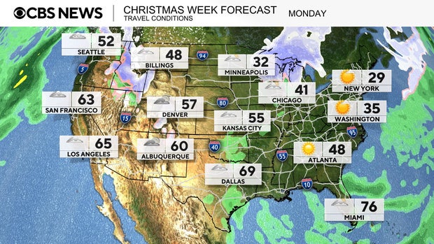
For those who are trying to travel on Monday, the more difficult regions will be in the Upper Midwest and in the northern Rockies. Falling snowflakes can be found in states like Idaho, western Montana, northern Minnesota, Wisconsin and northern Michigan. Interstate travel will be hazardous through parts of I-15, I-90, I-84, I-94 and I-75.
CBS News
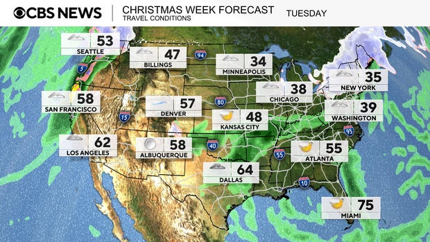
The wintry weather conditions shift from the Great Lakes region into the Northeast on Tuesday. Cold air pushes through to bring upwards of a half a foot of snow to the interior Northeast.
Moisture from the Gulf of Mexico will bring rain showers to the Mississippi Valley. In the West, the next atmospheric river will deliver rain to the lower elevations, with snow falling in the Cascade Mountains. Hazardous interstate travel conditions will be found along I-5, I-90, I-94, I-80, I-81 and even parts of I-95 up the East Coast.
CBS News
Map of snow forecast for Christmas Day 2024
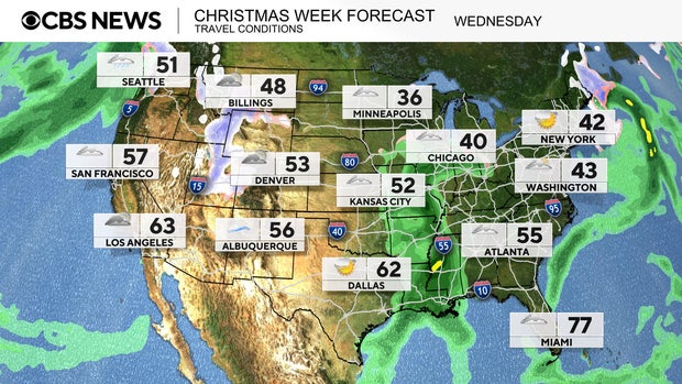
On Wednesday, Christmas Day, not many locations will see the fresh snowfall of picture-book holidays.
The definition of a “white Christmas” by the National Weather Service is having at least 1 inch of snow on the ground on Christmas morning. The only areas likely to meet that qualification on Christmas Day this year will be in the Rockies and along the U.S.-Canada border.
The moisture from the atmospheric river in the West will move into the Rockies to bring light snow to the higher elevations.
CBS News
Elsewhere, rain showers stick around in the Mississippi Valley, making for a soggy Christmas Day. Temperatures are forecast to be well above the freezing mark most places, which means precipitation will mainly be rain. Messy travel on Christmas could be found along Interstate 40, I-55, I-40, I-70, I-80 and I-90.
On Thursday, the next round of weather moves into the Northwest. Lower elevation rain can be expected along I-5, while in the interior Northwest.heavier snowfall is forecast in the Cascades and down into the Sierra Nevada mountains. Lingering rain showers continue in the Mississippi Valley and into parts of the Midwest.
Are white Christmases getting rarer?
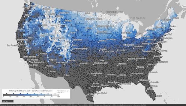
The National Oceanic and Atmospheric Administration has tracked snowfall data across the U.S. for years, and says there have been some notable changes over the past four decades, “consistent with the reality of long-term warming.”
When comparing the average probability of Christmas snowfall from 1981-2010 to the period from 1991-2020, NOAA says, “More areas experienced decreases in their chances of a white Christmas than experienced increases.”
The NOAA map below shows areas with the highest historic probability of seeing a white Christmas. Areas shaded in light blue have a higher than average chance, while the northern and mountain locations marked in white have historically had snow on Christmas at least 90% of the time.
NOAA/Climate.gov
You can explore an interactive version of the map on NOAA’s website here.


