CBS News
Heavy rain in Japan leaves 1 dead, several others missing, as region continues recovering from earthquake

Heavy rain pounded Japan’s northcentral region of Noto on Saturday which triggered landslides and floods and left one person dead and several missing, officials said.
The deluges caused swollen rivers to overflow, flooding homes and stranding some residents in the region still recovering from the deadly Jan. 1 earthquake.
The Japan Meteorological Agency issued the highest level of heavy rain across several cities in the Ishikawa prefecture, including hard-hit cities Suzu and Wajima on the northern coast of the Noto peninsula.
In Suzu, one person died and another was missing after being swept in floodwaters. One other went missing in the nearby town of Noto, according to the prefecture.
In Wajima, four people were missing following a landslide at a construction site. They were among 60 construction workers repairing a tunnel damaged by January’s quake, NHK said, adding that one other was missing due to floods at a different location in the city.
NHK footage at a coastal area of Wajima showed a wooden house torn and tilted after it was apparently hit by a landslide from a steep hill, with muddy water still flowing down. No injuries were reported from the site.
In Noto town, two people were seriously injured while visiting their quake-damaged home when a landslide struck them.
At least 16 rivers in Ishikawa breached their banks as of Saturday afternoon, according to the Land and Infrastructure Ministry. Residents were urged to use maximum caution against possible mudslides and building damage.
By late afternoon Saturday, about 1,350 residents were taking shelter at designated community centers, school gymnasiums and other town facilities, authorities said.
Up to 20 centimeters (7.8 inches) of rainfall is predicted in the region within the next 24 hours through Sunday noon, due to the rainbands that cause torrential rain above the Hokuriku region, JMA said.
“Heavy rain is hitting the region that had been badly damaged by the Noto earthquake, and I believe many people are feeling very uneasy,” said Chief Cabinet Secretary Yoshimasa Hayashi.
Hayashi said the government “puts people’s lives first” and its priority was search and rescue operations. He also called on the residents to pay close attention to the latest weather and evacuation advisories and take precautions early, adding that the Self Defense Force troops have been dispatched to Ishikawa to join rescue efforts.
A number of roads flooded by muddy water were also blocked. Hokuriku Electric Power Co. said about 6,500 homes were without power. Traffic lights were out in the affected areas. Many homes were also without water supply.
Heavy rain also fell in nearby northern prefectures of Niigata and Yamagata, threatening flooding and other damages, officials said.
In January, a series of powerful earthquakes off central Japan’s west coast damaged homes, started a fire, prompted tsunami warnings and left tens of thousands without power as residents were urged to seek higher ground.
CBS News
Why Luigi Mangione’s federal charges could lead to death penalty

Watch CBS News
Be the first to know
Get browser notifications for breaking news, live events, and exclusive reporting.
CBS News
Americans face holiday travel TSA crunch if government shuts down

Watch CBS News
Be the first to know
Get browser notifications for breaking news, live events, and exclusive reporting.
CBS News
Will it snow on Christmas? Maps show weather forecasts for 2024

With Christmas only a few days away, many Americans may be dreaming of a white Christmas, but few will end up walking in a winter wonderland. The warm and above-average temperatures in the weather forecast across the continental U.S. for Christmas week of 2024 are expected to keep any precipitation that falls as rain, not snow, for many parts of the country.
Where is most likely to get snow on Christmas?
If you’re looking for fluffy white flakes, some spots have a better chance than others.
This year, the only parts of the U.S. likely to see a white Christmas will be in the Rocky Mountains and along the U.S. border with Canada. That includes some northern areas of North Dakota, Minnesota, Wisconsin, Michigan, upstate New York, Vermont, New Hampshire and Maine.
Weather forecast for holiday travel
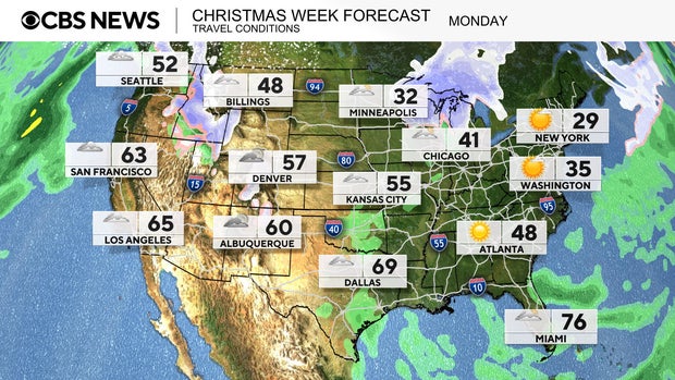
For those who are trying to travel on Monday, the more difficult regions will be in the Upper Midwest and in the northern Rockies. Falling snowflakes can be found in states like Idaho, western Montana, northern Minnesota, Wisconsin and northern Michigan. Interstate travel will be hazardous through parts of I-15, I-90, I-84, I-94 and I-75.
CBS News
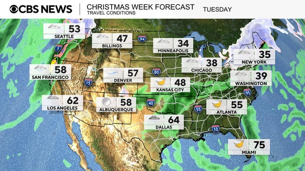
The wintry weather conditions shift from the Great Lakes region into the Northeast on Tuesday. Cold air pushes through to bring upwards of a half a foot of snow to the interior Northeast.
Moisture from the Gulf of Mexico will bring rain showers to the Mississippi Valley. In the West, the next atmospheric river will deliver rain to the lower elevations, with snow falling in the Cascade Mountains. Hazardous interstate travel conditions will be found along I-5, I-90, I-94, I-80, I-81 and even parts of I-95 up the East Coast.
CBS News
Map of snow forecast for Christmas Day 2024
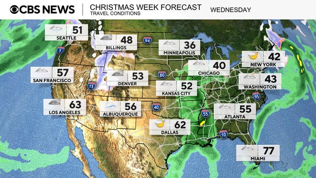
On Wednesday, Christmas Day, not many locations will see the fresh snowfall of picture-book holidays.
The definition of a “white Christmas” by the National Weather Service is having at least 1 inch of snow on the ground on Christmas morning. The only areas likely to meet that qualification on Christmas Day this year will be in the Rockies and along the U.S.-Canada border.
The moisture from the atmospheric river in the West will move into the Rockies to bring light snow to the higher elevations.
CBS News
Elsewhere, rain showers stick around in the Mississippi Valley, making for a soggy Christmas Day. Temperatures are forecast to be well above the freezing mark most places, which means precipitation will mainly be rain. Messy travel on Christmas could be found along Interstate 40, I-55, I-40, I-70, I-80 and I-90.
On Thursday, the next round of weather moves into the Northwest. Lower elevation rain can be expected along I-5, while in the interior Northwest.heavier snowfall is forecast in the Cascades and down into the Sierra Nevada mountains. Lingering rain showers continue in the Mississippi Valley and into parts of the Midwest.
Are white Christmases getting rarer?
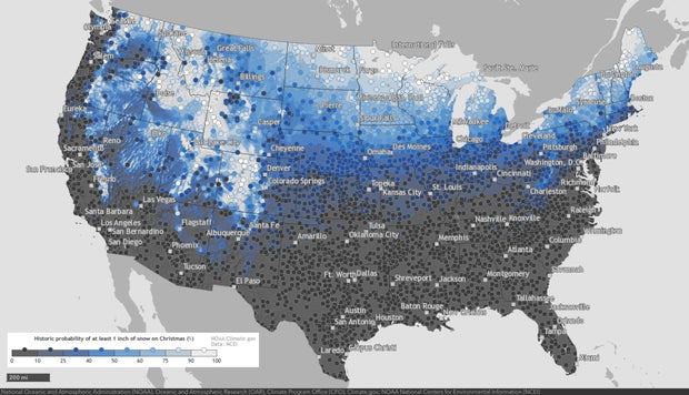
The National Oceanic and Atmospheric Administration has tracked snowfall data across the U.S. for years, and says there have been some notable changes over the past four decades, “consistent with the reality of long-term warming.”
When comparing the average probability of Christmas snowfall from 1981-2010 to the period from 1991-2020, NOAA says, “More areas experienced decreases in their chances of a white Christmas than experienced increases.”
The NOAA map below shows areas with the highest historic probability of seeing a white Christmas. Areas shaded in light blue have a higher than average chance, while the northern and mountain locations marked in white have historically had snow on Christmas at least 90% of the time.
NOAA/Climate.gov
You can explore an interactive version of the map on NOAA’s website here.


