CBS News
Destruction in Gaza from Israel-Hamas war revealed and mapped using satellite data


Israeli military operations in Gaza have killed almost 42,000 people since Oct. 7, 2023, according to the Ministry of Health in the Hamas-run Palestinian territory, the majority of them women and children.
In addition to lives lost, the United Nations estimates that the war has displaced 90% of Gaza’s roughly 2.3 million people. Many of them — unable to leave the embattled enclave — have been displaced multiple times within Gaza as they try to escape the Israeli airstrikes that have decimated its towns and cities.
As of January, the war had caused around $18.5 billion in damage to infrastructure in Gaza, according to the U.N. and the World Bank. That figure is almost equal to the entire combined GDP of the Palestinian territories (Gaza and the much larger Israeli-occupied West Bank) in the year before Hamas sparked the ongoing war with its Oct. 7 terrorist attack.

Mahmoud ssa/Anadolu/Getty
Most of the damage and destruction has been to housing (72% as of January), but other, critical infrastructure has also been affected. The U.N. and World Bank said 84% of health facilities and 92% of primary roads had been damaged or totally destroyed by January, and the bombing has continued since then.
How to assess destruction in Gaza
It has not been possible to comprehensively map destruction in Gaza from the ground. International journalists have not been allowed inside Gaza, apart from on highly restricted tours offered by the Israeli military, since the war started.
Palestinian journalists covering the conflict have had minimal security and been subjected to evacuation orders and restrictions on their movements like everyone else in the enclave. At least 116 journalists and media workers have been killed in Gaza since the war started, according to The Committee to Protect Journalists.
Given the difficulties of on-the-ground assessment, a team of researchers based in the U.S. have used data and other resources from the European Space Agency and NASA to map indicators of damage in conflict zones, including Gaza.
“The satellite data, specifically, is not a picture like you would think from a normal camera,” Corey Scher, at the City University of New York, explained to CBS News. “This is radar, so it shoots a burst of radar into the Earth that echoes back to the sensor, and we can get an idea of this three dimensional structure and arrangement of an area in a way that you don’t get with an optical image.”
The technique allows the team to track indicators of destruction more quickly than is possible by analyzing traditional satellite imagery, which can take many weeks, Scher said.
Mapping the situation on the ground
CBS News has used data provided by Scher and Jamon Van Den Hoek, an Associate Professor of Geography at Oregon State University who’s also worked on the project, to map the indicators of destruction in Gaza over the course of the war in an effort to reveal the overall extent of the damage to infrastructure.
Scroll through the map below to see how the damage escalated over the course of the last 12 months.
“Over time, it becomes inevitable that people are displaced to areas where there are just – there is no safety, there is no shelter that can support… the population. The food insecurity, lack of access to water, just the constant uprooting on top of the background of damage is also extremely unique in this conflict,” Van Den Hoek said.

“The pace of the bombing, the breadth of the bombing, that resulted in this damage was extremely unique,” said Van Den Hoek, adding that it was the most destruction he had seen in any of the conflicts he’s looked at in his work with Oregon State’s Conflict Ecology lab.
“Over time, it becomes inevitable that people are displaced to areas where there are just – there is no safety, there is no shelter that can support… the population. The food insecurity, lack of access to water, just the constant uprooting on top of the background of damage is also extremely unique in this conflict,” said Van Den Hoek.
“It’s beyond the brick and stone”
“The damage has been colossal and also unprecedented and unheard of in the history of the U.N.,” Juliette Touma, communications director for UNWRA, the U.N. agency that supports Palestinian refugees, told CBS News.
Touma said that of the 190 buildings UNRWA had in Gaza before the war, two thirds had been either damaged or totally destroyed, with several being hit multiple times.
“It’s beyond the brick and stone,” Touma said. “It’s about what these buildings and structures used to represent — and the vast majority of these buildings were schools for children.”
Before Oct. 7, 2023, UNWRA provided education services for about 300,000 children across Gaza. By September 2024, Touma said all the school buildings still standing were being used as shelters for displaced people.
In January 2024, Israel accused 12 UNWRA employees of participating in the Oct. 7 attacks. After an internal U.N. investigation, the global body fired nine of its staffers, accepting that they may have taken part in the attacks. The agency employs some 13,000 people in Gaza and, as of September 2024, the U.N. said at least 222 of its team members had been killed in the war.
“What is the fate of these children who used to go to these buildings that are now either destroyed or severely damaged, or they continue to house people and continue to provide shelter for displaced families?” Touma said. “Even if there is a miracle and we have a cease-fire tomorrow, what will this mean for education? And how will children be able to go back to school? Because… 70% of our schools in Gaza cannot be used.”
The destruction and successive Israeli evacuation orders have forced many people to flee to increasingly difficult places to survive, including hundreds of thousands crammed into the coastal area of al-Mawasi, west of Khan Younis. Israel’s military has designated al-Mawasi a humanitarian zone, but before the war, it had “no facilities for human beings,” Touma said.
“People just started setting up shop there, meaning putting these plastic sheeting with, you know, wooden boards and living anywhere and everywhere,” she told CBS News. “At some point, Mawasi had a million people.”
But even al-Mawasi has been bombed. The most deadly attack was in July, when 90 people were killed and 300 wounded. Israel said it targeted and killed Mohammed Deif, the head of Hamas’ military wing, with the strike.
“A damaged building is a proxy for a displaced family, a displaced group of, you know, a school or a bakery,” Scher said. “It’s also an indicator of a potential hazard for an unexploded ordnance… It’s a proxy for everything that’s happening on the ground.”


Watch CBS News
Be the first to know
Get browser notifications for breaking news, live events, and exclusive reporting.

Watch CBS News
Be the first to know
Get browser notifications for breaking news, live events, and exclusive reporting.

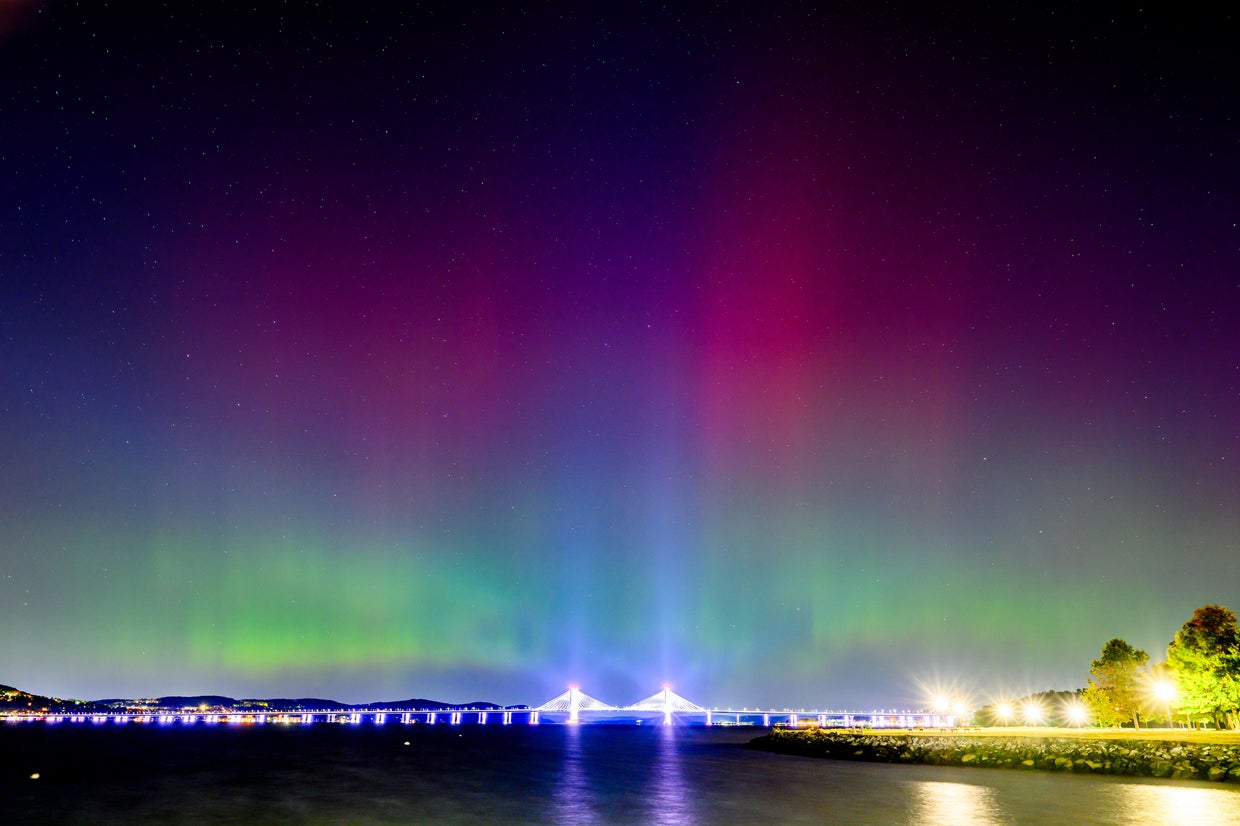
The northern lights made an incredible display over much of the United States on Thursday — and might make a return appearance Friday night.
The aurora borealis was visible as far south as Florida on Thursday. Photos show the sky lit up in red and purple, even in some brightly-lit areas like New York City and Chicago.
The strong geomagnetic storm that created such a show has subsided, according the National Oceanic and Atmospheric Administration, but some parts of the U.S. may again see the northern lights tonight. Here’s what to know.
Roy Rochlin / Getty Images
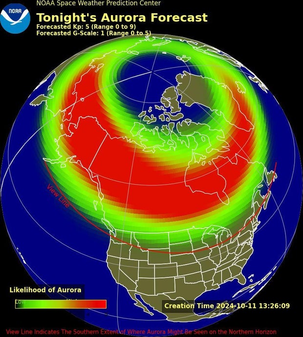
Where will the northern lights be visible tonight?
The northern lights will be visible for parts of the northern U.S., according to the NOAA Space Weather Prediction Center’s aurora forecast. The aurora will be visible over much of Canada and Alaska, but the northern lights can also be seen from as far as 620 miles away if the conditions are right, NOAA says.
Parts of Idaho, South Dakota, Minnesota and Wisconsin may be able to see the lights Friday night. On the East Coast, the aurora might be visible in northern New York and parts of Vermont and New Hampshire. Areas of Maine may also see the northern lights.
The lights will appear to the north when it’s dark outside. If you can’t see them with the naked eye, they may be visible through a phone camera or other device.
NOAA Space Weather Prediction Center
What time will the northern lights be most visible?
The northern lights are most visible just after sunset or just before sunrise, NOAA said. The aurora is not visible during the day. Dark, cloudless skies with little artificial light provide the best viewing experience.

Ross Harried/NurPhoto via Getty Images
Why have the northern lights been so visible lately?
Over the last several months the sun has been incredibly active, unleashing a series of coronal mass ejections from its surface, CBS Boston reported. That’s resulted in multiple visible aurora shows.
The geomagnetic storm responsible for Thursday’s stunning skies is now subsiding, CBS Boston reported. That means there will be less chance of seeing the aurora on Friday, but there may be more opportunities in the future.
Shawn Dahl, a forecast coordinator with the Space Weather Prediction Center, told CBS Boston that the northern lights have been so intense lately because of where the sun is in its 11-year solar cycle. Dahl said that “we are in the midst of solar maximum.”

Heather Kepple
“What that means is the sun is now this twisted-up mass of strong magnetic fields, and some of these are so localized and intense they reveal themselves as these sunspot groups,” Dahl said. “That’s the source of a bunch of the space weather storms that we’re looking for and predict.”
What causes the northern lights?
The northern lights are caused by interactions between the sun’s solar winds and the Earth’s protective magnetic field, according to NOAA. Those two phenomenons result in geomagnetic storms and increased geomagnetic activity.
The higher the geomagnetic activity is, the better your odds are of seeing the aurora. Increased geomagnetic activity means the aurora will become brighter, more active and visible farther from the poles of the planet, NOAA said.
Even moderate solar wind creates the aurora, NOAA said, so there is usually a weak aurora visible from somewhere on Earth. The best places to see these weaker auroras is close to the planet’s poles, like in Greenland or southern Argentina. If you see the aurora near the North Pole, it’s nicknamed the northern lights. The same phenomenon near the South Pole is called the southern lights.